 DORIS Geodaten-Katalog
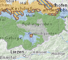
Rotwildzonierung
Zonierung des Rotwildes innerhalb von Oberösterreich.
Simple
Metadata
- File identifier
- 0F2120E9-DDE1-40E1-A143-3F09A4A41A44 XML
- Metadata language
- de
- Metadata standard name
-
OENORM A 2270
- Metadata standard version
-
Ausgabe 2016
- Date stamp
- 2026-01-19T09:39:42.436Z
- Metadata author
-
Organisation name Individual name Electronic mail address Role Amt der Oö. Landesregierung
DI, Roland Paumann
Point of contact
- Hierarchy level
- Dataset
- Dataset URI
-
H:\arcgis\Layerfiles\PlanungEntwicklung\Grenzen\Rotwildzonierung.lyrx
Identification
- Alternate title
-
DORIS_PE.GISDB.ROTWILDZONIERUNG
- Date ( Creation)
- 2025-05-01
- Date ( Publication)
- 2025-05-01
- Presentation form
- Digital map
- Point of contact
-
Organisation name Individual name Electronic mail address Role Amt der Oö. Landesregierung
DI, Roland Paumann
Point of contact
Descriptive keywords
- OGD Categories
-
-
Geographie und Planung
-
Land- und Forstwirtschaft
-
- OGD Keyword
-
-
Rotwildzonierung
-
Rotwild
-
- Keywords
-
-
Rotwildzonierung
-
Rotwild
-
OGDFreigabe
-
Internetfreigabe
-
Legal constraints
- Use limitation
-
no limitations
Legal constraints
- Access constraints
- Other restrictions
- Other constraints
-
Creative Commons Namensnennung 4.0 International (CC BY 4.0) https://creativecommons.org/licenses/by/4.0/deed.de
- Classification
- Unclassified
Technical information
- Spatial representation type
- Vector
- Denominator
- 1
- Metadata language
- de
- Character set
- UTF8
- Topic category
-
- Boundaries
- Farming
Spatial Information
N
S
E
W
))
Temporal extent
Temporal extent
Data quality information
- Hierarchy level
- Dataset
- Statement
-
Abgrenzung durch Forstdienst, Behörden, Jägerschaft
Conformance result
- Date ( Creation)
- 2025-05-01
- Date ( Publication)
- 2025-05-01
- Explanation
-
keine Angabe
- Pass
- No
Reference System Information
- Projection
- EPSG:31255
Distribution Information
- Distribution format
-
Name Version Specification shapefile 1.0
ESRI Shapefile Technical Description
Overviews
Spatial extent
N
S
E
W
Provided by

Associated resources
Not available