 DORIS Geodaten-Katalog
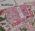
Urmappe
Mit dem Grundsteuerpatent vom 23. Dezember 1817 stellte Kaiser Franz I. die Besteuerung auf ganz neue Grundlagen. So sollte nun der Reinertrag, der sich aus dem Boden erwirtschaften ließ, für alle in gleichem Maße als Basis für die staatlichen Abgaben herangezogen werden.
Dazu wurden 8141 Mappenblätter digital erfasst und georeferenziert.
In 34 Katastralgemeinden wurden die fehlenden Urmappenblätter durch 102 Indikationsskizzen ersetzt.
Simple
Metadata
- File identifier
- 119BDA22-5971-4618-9B86-819E7B09B50E XML
- Metadata language
- de
- Metadata standard name
-
OENORM A 2270
- Metadata standard version
-
Ausgabe 2016
- Date stamp
- 2026-01-22T14:05:29.894Z
- Metadata author
-
Organisation name Individual name Electronic mail address Role Amt der Oö. Landesregierung
Ing. Andreas Ennikl
Point of contact
- Hierarchy level
- Dataset
- Dataset URI
-
H:\arcgis\Layerfiles\DORIS_Rasterdaten\Urmappe\Urmappe.lyr
Identification
- Alternate title
-
H:\d_urmappe\urmappe.gdb
- Date ( Publication)
- 2005-01-01
- Presentation form
- Digital map
- Point of contact
-
Organisation name Individual name Electronic mail address Role Amt der Oö. Landesregierung
Mag. Peter Zauner
Point of contact
Descriptive keywords
- OGD Kategorien ( Theme)
-
-
Verwaltung und Politik
-
Geographie und Planung
-
- OGD Keyword
-
-
1824
-
1830
-
- Keywords
-
-
1824
-
1830
-
Internetfreigabe
-
OGDFreigabe
-
OGDnoExport
-
Legal constraints
- Use limitation
-
no limitations
Legal constraints
- Access constraints
- Other restrictions
- Other constraints
-
Creative Commons Namensnennung 4.0 International (CC BY 4.0) https://creativecommons.org/licenses/by/4.0/deed.de
- Classification
- Unclassified
Technical information
- Spatial representation type
- Grid
- Denominator
- 1
- Metadata language
- de
- Character set
- UTF8
- Topic category
-
- Boundaries
- Society
Spatial Information
))
Temporal extent
Temporal extent
Data quality information
- Hierarchy level
- Dataset
- Statement
-
keine Angabe
Conformance result
- Date ( Publication)
- 2005-01-01
- Explanation
-
keine
- Pass
- No
Reference System Information
- Projection
- EPSG:31255
Distribution Information
- Distribution format
-
Name Version Specification jp2 1.0
Overviews
Spatial extent
Provided by
