 DORIS Geodaten-Katalog
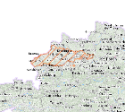
Gespannte Grundwässer Oberösterreich
Gebiete mit gespanntem Grundwasser gemäß §31c Abs. 5 WRG.
Simple
- Alternate title
-
DORIS_U.GISDB.GW_GESPANNT_GEM_WRG
- Date (Publication)
- 2011-05-05
- Citation identifier
- https://data.inspire.gv.at/0021/22EEE036-ECC1-4168-8AFF-7515C8E83B37
- Point of contact
-
Organisation name Individual name Electronic mail address Role Amt der OÖ. Landesregierung
Mag., Harald, Schön
Point of contact
- Maintenance and update frequency
- Annually
-
GEMET - Concepts, version 2.4
-
-
Grundwasser
-
-
OGD Kategorien
-
-
Umwelt
-
-
OGD Keyword
-
-
Bewirtschaftungsgebiete
-
Schutzgebiete
-
Berichterstattungseinheiten
-
Erdwärmesonden
-
Tiefensonden
-
- Keywords
-
-
Bewirtschaftungsgebiete
-
Schutzgebiete
-
geregelte
-
Berichterstattungseinheiten
-
Erdwärmesonden
-
Tiefensonden
-
Internetfreigabe
-
OGDFreigabe
-
- Use constraints
- Other restrictions
- Other constraints
- Creative Commons Namensnennung 4.0 International (CC BY 4.0)
- Other constraints
-
Datenquelle: Land Oö., doris.at
- Access constraints
- Other restrictions
- Classification
- Unclassified
- Spatial representation type
- Vector
- Denominator
- 1
- Language
- Deutsch
- Character set
- UTF8
- Topic category
-
- Environment
- Geoscientific information
N
S
E
W
))
- Unique resource identifier
- EPSG:31255
- Geometric object type
- Surface
- Distribution format
-
Name Version ESRI Shapefile
1.0
- Distributor contact
-
Organisation name Individual name Electronic mail address Role Land Oberösterreich - Amt der OÖ- Landesregierung
Point of contact
Digital transfer options
- OnLine resource
-
Protocol Linkage Name https://e-gov.ooe.gv.at/at.gv.ooe.dorisdaten/DORIS_U/GW_GESPANNT_GEM_WRG.zip
- Hierarchy level
- Dataset
- Statement
-
Daten stammen von der Abteilung Wasserwirtschaft.
Metadata
- File identifier
- 22EEE036-ECC1-4168-8AFF-7515C8E83B37 XML
- Metadata language
- Deutsch
- Character set
- UTF8
- Hierarchy level
- Dataset
- Date stamp
- 2026-04-07T08:28:27.261Z
- Metadata standard name
-
ISO 19115:2003/19139
- Metadata standard version
-
1.0
- Metadata author
-
Organisation name Individual name Electronic mail address Role Amt der OÖ. Landesregierung
Mag., MSc, Julia, Pichler
Point of contact
- Dataset URI
-
H:\arcgis\Layerfiles\Umwelt\Geowissenschaften\Gespannte Grundwässer gemäss WRG.lyr
Overviews
Spatial extent
N
S
E
W
Provided by

Associated resources
Not available