 DORIS Geodaten-Katalog
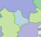
Bezirksgerichtsgrenzen OÖ
Abgrenzungspolygone der Bezirksgerichtsgrenzen in Oberösterreich basierend auf BGBl. II Nr. 197/2015. Enthält die Bezirksgerichtsnamen und -nummern.
Stand: 01.10.2025
Simple
Metadata
- File identifier
- 2AB56B93-656E-414A-8D00-14F4C2F9EFCD XML
- Metadata language
- de
- Character set
- UTF8
- Metadata standard name
-
OENORM A 2270
- Metadata standard version
-
Ausgabe 2016
- Date stamp
- 2026-03-21T11:13:28.115Z
- Metadata author
-
Organisation name Individual name Electronic mail address Role Amt der Oö. Landesregierung
MSc (GIS), Christoph, Kastl
Point of contact
- Hierarchy level
- Dataset
- Dataset URI
-
H:\arcgis\Layerfiles\DORIS_Basisdaten\Grenzen\Bezirksgerichte.lyr
Identification
- Alternate title
-
DORIS_Basisdaten.GISDB.BEZIRKSGERICHTSGRENZEN_OOE
- Date ( Publication)
- 2008-04-23
- Date ( Creation)
- 2008-04-23
- Date ( Revision)
- 2025-10-01
- Point of contact
-
Organisation name Individual name Electronic mail address Role Amt der Oö. Landesregierung
MSc (GIS), Christoph, Kastl
Point of contact
Descriptive keywords
- OGD Kategorien ( Theme)
-
-
Geographie und Planung
-
Verwaltung und Politik
-
- OGD Keyword
-
-
Gerichtsbezirk
-
Gerichtsbezirksgrenzen
-
Gerichtsbezirkgrenzen
-
- Keywords
-
-
Gerichtsbezirk
-
Gerichtsbezirksgrenzen
-
Gerichtsbezirkgrenzen
-
Internetfreigabe
-
OGDFreigabe
-
Legal constraints
- Use limitation
-
no limitations
Legal constraints
- Access constraints
- Other restrictions
- Other constraints
-
Creative Commons Namensnennung 4.0 International (CC BY 4.0) https://creativecommons.org/licenses/by/4.0/deed.de
- Classification
- Unclassified
Technical information
- Denominator
- 1000000
- Metadata language
- de
- Character set
- UTF8
- Topic category
-
- Boundaries
Spatial Information
))
Temporal extent
Temporal extent
Data quality information
- Hierarchy level
- Dataset
- Statement
-
Datengrundlage ist die DKM. Rechtsgrundlage ist das BGBl. II Nr. 197/2015. Aufgrund dessen die Gemeinden dem jeweiligen Gerichtsbezirk zugeordnet werden.
Conformance result
- Date ( Creation)
- 2010
- Date ( Revision)
- 2013-10-01
- Explanation
-
unbekannt
- Pass
- No
Reference System Information
- Projection
- EPSG:31255
Distribution Information
- Distribution format
-
Name Version Specification shapefile 1.0
ESRI Shapefile Technical Description
Overviews
Spatial extent
Provided by
