 DORIS Geodaten-Katalog
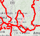
Radwegenetz
Die Radwege sind vorrangig oder ausschließlich für die Benutzung mit dem Fahrrad vorgesehen. Es handelt sich um überregionale, touristische Radwege.
Simple
Metadata
- File identifier
- 2FAF3A8C-A855-412A-8631-3A6FB6F935E7 XML
- Metadata language
- de
- Character set
- UTF8
- Metadata standard name
-
OENORM A 2270
- Metadata standard version
-
Ausgabe 2016
- Date stamp
- 2026-03-23T07:29:59.096Z
- Metadata author
-
Organisation name Individual name Electronic mail address Role Amt der OÖ. Landesregierung
Bernhard, Gibitz
Point of contact
- Hierarchy level
- Dataset
- Dataset URI
-
H:\arcgis\Layerfiles\Verkehr\Verkehrswesen\Radwegenetz Oö..lyr
Identification
- Alternate title
-
DORIS_V.GISDB.RADWEGE
- Date ( Revision)
- 2025-11-27
- Date ( Publication)
- 2013-08-21
- Point of contact
-
Organisation name Individual name Electronic mail address Role Amt der OÖ. Landesregierung
Ing., Andreas, Höflinger
Point of contact
Descriptive keywords
- OGD Kategorien ( Theme)
-
-
Verkehr und Technik
-
- OGD Keyword
-
-
Verkehrswesen
-
Fahrradwege
-
- Keywords
-
-
Verkehrswesen
-
Fahrradwege
-
Internetfreigabe
-
Legal constraints
- Use limitation
-
no limitations
Legal constraints
- Access constraints
- Other restrictions
- Other constraints
-
Creative Commons Namensnennung 4.0 International (CC BY 4.0) https://creativecommons.org/licenses/by/4.0/deed.de
- Classification
- Unclassified
Technical information
- Denominator
- 1
- Metadata language
- de
- Character set
- UTF8
- Topic category
-
- Economy
- Society
- Transportation
- Utilities communication
Spatial Information
))
Temporal extent
Temporal extent
Data quality information
- Hierarchy level
- Dataset
- Statement
-
Die Radwege wurden auf Basis der Orthofotos digitalisiert.
Conformance result
- Date ( Creation)
- 2010-01-02
- Date ( Revision)
- 2025-09-23
- Explanation
-
unbekannt
- Pass
- No
Reference System Information
- Projection
- EPSG:31255
Distribution Information
- Distribution format
-
Name Version Specification shapefile 1.0
ESRI Shapefile Technical Description
Overviews
Spatial extent
Provided by
