 DORIS Geodaten-Katalog
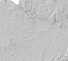
DGM - Schummerung als 5m-Raster
Schummerungsbild des Digitalen Geländemodells (DGM) als 5m-Raster, abgeleitet aus den aktuellsten Airborne Laserscanning (ALS) Befliegungen.
Simple
Metadata
- File identifier
- 4151884E-9969-4F9E-80AD-D6AB063797E2 XML
- Metadata language
- de
- Metadata standard name
-
OENORM A 2270
- Metadata standard version
-
Ausgabe 2016
- Date stamp
- 2026-05-21T12:16:32.108Z
- Metadata author
-
Organisation name Individual name Electronic mail address Role Amt der OÖ. Landesregierung
MSc, Bernhard, Kosar
Point of contact
- Hierarchy level
- Dataset
- Dataset URI
-
H:\arcgis\Layerfiles\DORIS_Rasterdaten\DGM-Schummerung als 5m-Raster Land Oberösterreich.lyr
Identification
- Alternate title
-
H:\d_schummerung\SCHUMMERUNG.gdb/DGM_5M
- Date ( Creation)
- 2013-11-28
- Date ( Publication)
- 2013-11-28
- Date ( Revision)
- 2026-05-21
- Point of contact
-
Organisation name Individual name Electronic mail address Role Amt der OÖ. Landesregierung
MSc, Bernhard, Kosar
Processor
Descriptive keywords
- OGD Kategorien ( Theme)
-
-
Geographie und Planung
-
- OGD Keyword
-
-
DGM
-
Geländemodell
-
Schummerung
-
ALS
-
- Keywords
-
-
DGM
-
Geländemodell
-
Schummerung
-
ALS
-
Internetfreigabe
-
OGDFreigabe
-
OGDnoExport
-
Legal constraints
- Use limitation
-
Urheberrecht
Legal constraints
- Access constraints
- Other restrictions
- Other constraints
-
Creative Commons Namensnennung 4.0 International (CC BY 4.0) https://creativecommons.org/licenses/by/4.0/deed.de
- Classification
- Unclassified
Technical information
- Spatial representation type
- Grid
- Metadata language
- de
- Character set
- UTF8
- Topic category
-
- Elevation
- Imagery base maps earth cover
Spatial Information
))
Temporal extent
Temporal extent
Data quality information
- Hierarchy level
- Dataset
- Statement
-
keine Angabe
Reference System Information
- Projection
- EPSG:31255
Distribution Information
- Distribution format
-
Name Version Specification shapefile 1.0
ESRI Shapefile Technical Description
Overviews
Spatial extent
Provided by
