 DORIS Geodaten-Katalog
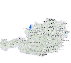
Windrichtung 8 Stunden nach Sonnenuntergang im Zentralraum OÖ
Windrichtung 8 Stunden nach Sonnenuntergang, berechnet mit dem Modell KLAM21 von der ZAMG; Grundlagenkarte für die Stadtklimatologie
Simple
Metadata
- File identifier
- 5AC82A9A-3E17-4740-A26E-E6B7A82A1405 XML
- Metadata language
- de
- Metadata standard name
-
OENORM A 2270
- Metadata standard version
-
Ausgabe 2016
- Date stamp
- 2026-01-19T09:29:25.196Z
- Metadata author
-
Organisation name Individual name Electronic mail address Role Amt der Oö. Landesregierung
Mag., MSc, Julia, Pichler
Point of contact
- Hierarchy level
- Dataset
- Dataset URI
-
H:\arcgis\Layerfiles\Umwelt\CLAIRISA\Windrichtung_8Std_nach_Sonnenuntergang.lyrx
Identification
- Alternate title
-
DORIS_U.GISDB.KLIMAANALYSE_ZENTRALRAUM_WINDRICHTUNG_8STD
- Date ( Creation)
- 2023-03-14
- Date ( Publication)
- 2023-03-14
- Presentation form
- Digital map
- Point of contact
-
Organisation name Individual name Electronic mail address Role Amt der Oö. Landesregierung
Mag. Stefan Oitzl
Point of contact
Descriptive keywords
- OGD Categories
-
-
Umwelt
-
- OGD Keyword
-
-
Luft
-
Atmosphäre
-
Kaltluft
-
Kaltluftabfluss
-
Windrichtung
-
Stadtklimatologie
-
Regionalklimatologie
-
- Keywords
-
-
Luft
-
Atmosphäre
-
Kaltluft
-
Kaltluftabfluss
-
Windrichtung
-
Stadtklimatologie
-
Regionalklimatologie
-
OGDnoExport
-
Internetfreigabe
-
Legal constraints
- Use limitation
-
no limitations
Legal constraints
- Access constraints
- Other restrictions
- Other constraints
-
Creative Commons Namensnennung 4.0 International (CC BY 4.0) https://creativecommons.org/licenses/by/4.0/deed.de
- Classification
- Unclassified
Technical information
- Spatial representation type
- Grid
- Denominator
- 1
- Metadata language
- de
- Character set
- UTF8
- Topic category
-
- Planning cadastre
Spatial Information
))
Temporal extent
Temporal extent
Data quality information
- Hierarchy level
- Dataset
- Statement
-
Mit dem Modell KLAM21 von der ZAMG berechnet; Grundlagenkarte für die Stadtklimatologie
Conformance result
- Date ( Creation)
- 2023-03-14
- Date ( Publication)
- 2010-12-08
- Explanation
-
keine
- Pass
- No
Reference System Information
- Projection
- EPSG:31255
Distribution Information
- Distribution format
-
Name Version Specification shapefile 1.0
ESRI Shapefile Technical Description
Overviews
Spatial extent
Provided by
