 DORIS Geodaten-Katalog
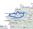
Grundwasserkörper thermal
"Abgrenzung von Grundwasserkörpern in OÖ; Geothermischer Horizont
Ein Wasserkörper ist eine kohärente Untereinheit einer Flussgebietseinheit, der die Umweltziele der Wasserrahmenrichtlinie (WRRL) erfüllen soll. Jede Flussgebietseinheit besteht aus zahlreichen Wasserkörpern.
Im DORIS sind drei Horizonte verfügbar:
1. Horizont: oberflächennahe GW-Körper
2. Horizont: thermischer GW-Körper
3. Horizont: tieferer GW-Körper"
Simple
Metadata
- File identifier
- 6E36EB89-875A-4517-9E65-CDA6744C2E09 XML
- Metadata language
- de
- Metadata standard name
-
OENORM A 2270
- Metadata standard version
-
Ausgabe 2016
- Date stamp
- 2026-06-22T13:22:33.484Z
- Metadata author
-
Organisation name Individual name Electronic mail address Role Amt der OÖ. Landesregierung
Prisca Heim BSc. MSc.
Custodian
- Hierarchy level
- Dataset
- Dataset URI
-
H:\arcgis\Layerfiles\Umwelt\WIS\GW-Koerper_thermal.lyrx
Identification
- Alternate title
-
DORIS_U.GISDB.GEW_KOERPER_THERMAL
- Date ( Publication)
- 2013-11-11
- Presentation form
- Digital map
- Point of contact
-
Organisation name Individual name Electronic mail address Role Amt der OÖ. Landesregierung
WIS-Kernteam
Point of contact
Descriptive keywords
- OGD Kategorien ( Theme)
-
-
Umwelt
-
- OGD Keyword
-
-
Umwelt
-
Geologie und Boden
-
Geowissenschaften
-
- Keywords
-
-
Umwelt
-
Geologie und Boden
-
Geowissenschaften
-
Internetfreigabe
-
OGDFreigabe
-
Legal constraints
- Use limitation
-
no limitations
Legal constraints
- Access constraints
- Other restrictions
- Other constraints
-
Creative Commons Namensnennung 4.0 International (CC BY 4.0) https://creativecommons.org/licenses/by/4.0/deed.de
- Classification
- Unclassified
Technical information
- Spatial representation type
- Vector
- Denominator
- 1
- Metadata language
- de
- Character set
- UTF8
- Topic category
-
- Environment
- Geoscientific information
Spatial Information
))
Temporal extent
Temporal extent
Data quality information
- Hierarchy level
- Dataset
- Statement
-
Von einem Fachbüro aus unterschiedlichen Grundlagen digitalisiert
Conformance result
- Date ( Publication)
- 2013-11-11
- Explanation
-
unbekannt
- Pass
- No
Reference System Information
- Projection
- EPSG:31255
Distribution Information
- Distribution format
-
Name Version Specification shapefile 1.0
ESRI Shapefile Technical Description
Overviews
Spatial extent
Provided by
