 DORIS Geodaten-Katalog
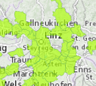
Bodenbündnisgemeinden
"Gemeinden in OÖ die dem Bodenbündnis angehören.
Das Boden-Bündnis ist ein Zusammenschluss von Städten und Gemeinden in Europa, die sich zum Ziel gesetzt haben, sich aktiv für einen nachhaltigen Umgang mit Böden einzusetzen."
Simple
Metadata
- File identifier
- 7DF01F69-7AB9-4193-A581-D5338D1BA6F3 XML
- Metadata language
- de
- Metadata standard name
-
OENORM A 2270
- Metadata standard version
-
Ausgabe 2016
- Date stamp
- 2026-01-19T09:30:34.417Z
- Metadata author
-
Organisation name Individual name Electronic mail address Role Amt der OÖ. Landesregierung
Mag., MSc, Julia, Pichler
Custodian
- Hierarchy level
- Dataset
- Dataset URI
-
H:\arcgis\Layerfiles\Umwelt\Geowissenschaften\Bodenbuendnisgemeinden.lyr
Identification
- Alternate title
-
DORIS_U.GISDB.BODENBUENDNISGEMEINDEN
- Date ( Revision)
- 2023-12-04
- Date ( Creation)
- 2013-01-07
- Date ( Publication)
- 2013-02-28
- Presentation form
- Digital map
- Point of contact
-
Organisation name Individual name Electronic mail address Role Amt der OÖ. Landesregierung
Mag. Dr., Thomas, Bauer
Point of contact
Descriptive keywords
- OGD Categories
-
-
Umwelt
-
- OGD Keyword
-
-
Umwelt
-
Geologie und Boden
-
Grenzen
-
- Keywords
-
-
Umwelt
-
Geologie und Boden
-
Grenzen
-
Internetfreigabe
-
OGDFreigabe
-
Legal constraints
- Use limitation
-
no limitations
Legal constraints
- Access constraints
- Other restrictions
- Other constraints
-
Creative Commons Namensnennung 4.0 International (CC BY 4.0) https://creativecommons.org/licenses/by/4.0/deed.de
- Classification
- Unclassified
Technical information
- Spatial representation type
- Vector
- Denominator
- 1
- Metadata language
- de
- Character set
- UTF8
- Topic category
-
- Boundaries
- Environment
- Geoscientific information
Spatial Information
))
Temporal extent
Temporal extent
Data quality information
- Hierarchy level
- Dataset
- Statement
-
Bodenbündnisgemeinden sind mit den Datensatz der Gemeinden in OÖ verknüpft.
Reference System Information
- Projection
- EPSG:31255
Distribution Information
- Distribution format
-
Name Version Specification shapefile 1.0
ESRI Shapefile Technical Description
Overviews
Spatial extent
Provided by
