 DORIS Geodaten-Katalog
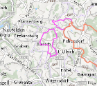
Gemeindewanderwege
Wanderwege für die Homepage Gesundes OÖ, welche in Form einer Bewegungslandkarte dargestellt werden. Zu den Wanderwegen werden Länge, Dauer, Höhenmeter und Schwierigkeitsgrad angegeben.
Simple
Metadata
- File identifier
- 8041391A-3CF8-4C94-9B11-7181D133F451 XML
- Metadata language
- de
- Metadata standard name
-
OENORM A 2270
- Metadata standard version
-
Ausgabe 2016
- Date stamp
- 2026-05-22T07:45:20.924Z
- Metadata author
-
Organisation name Individual name Electronic mail address Role Amt der Oö. Landesregierung
Christoph Kastl
Point of contact
- Hierarchy level
- Dataset
- Dataset URI
-
H:\arcgis\Layerfiles\SozialesGesundheit\GESUNDHEITSICHERHEIT\Gemeindewanderwege.lyrx
Identification
- Alternate title
-
DORIS_SG.GISDB.GEMEINDEWANDERWEGE
- Date ( Creation)
- 2024-06-06
- Date ( Publication)
- 2025-03-14
- Presentation form
- Digital map
- Point of contact
-
Organisation name Individual name Electronic mail address Role Amt der Oö. Landesregierung
Eva Kaser, BScN MPH
Point of contact
Descriptive keywords
- OGD Kategorien ( Theme)
-
-
Gesundheit
-
Sport und Freizeit
-
- OGD Keyword
-
-
Gesundheit
-
Gesunde
-
Gemeinde
-
Spazierwege
-
Laufstrecken
-
Nordic
-
Walking
-
- Keywords
-
-
Gesundheit
-
Gesunde
-
Gemeinde
-
Spazierwege
-
Laufstrecken
-
Nordic
-
Walking
-
Internetfreigabe
-
OGDFreigabe
-
Legal constraints
- Use limitation
-
no limitations
Legal constraints
- Access constraints
- Other restrictions
- Other constraints
-
Creative Commons Namensnennung 4.0 International (CC BY 4.0) https://creativecommons.org/licenses/by/4.0/deed.de
- Classification
- Unclassified
Technical information
- Spatial representation type
- Vector
- Denominator
- 1
- Metadata language
- de
- Character set
- UTF8
- Topic category
-
- Society
- Health
Spatial Information
))
Temporal extent
Temporal extent
Data quality information
- Hierarchy level
- Dataset
- Statement
-
Wanderwege wurden von den Gemeinden digitalisiert.
Conformance result
- Date ( Creation)
- 2024-06-06
- Explanation
-
keine Angabe
- Pass
- No
Reference System Information
- Projection
- EPSG:31255
Distribution Information
- Distribution format
-
Name Version Specification shapefile 1.0
ESRI Shapefile Technical Description
Overviews
Spatial extent
Provided by
