 DORIS Geodaten-Katalog
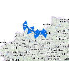
Wasserscheide Donau / Elbe
Einzugsgebiete sind durch Wasserscheiden abgegrenzte oberirdische Gebiete, aus denen Wasser ober- oder unterirdisch einem bestimmten Ort zufließt und dort als Durchfluss erfassbar ist. Die enthaltene Wasserscheide ist die zwischen Donau und Elbe
Simple
Metadata
- File identifier
- 915B3077-C5D2-4D54-9F79-AD1C4869C2F8 XML
- Metadata language
- de
- Metadata standard name
-
OENORM A 2270
- Metadata standard version
-
Ausgabe 2016
- Date stamp
- 2026-01-19T09:31:05.654Z
- Metadata author
-
Organisation name Individual name Electronic mail address Role Amt der OÖ. Landesregierung
Mag., MSc, Julia, Pichler
Custodian
- Hierarchy level
- Dataset
- Dataset URI
-
H:\arcgis\Layerfiles\Umwelt\Binnengewässer\Wasserscheide Donau _ Elbe.lyr
Identification
- Alternate title
-
DORIS_U.GISDB.WASSERSCHEIDE
- Date ( Creation)
- 2012-12-01
- Date ( Publication)
- 2012-12-01
- Date ( Revision)
- 2022-08-10
- Presentation form
- Digital map
- Point of contact
-
Organisation name Individual name Electronic mail address Role Amt der OÖ. Landesregierung
DI, Edith, Wakolbinger
Point of contact
Descriptive keywords
- OGD Categories
-
-
Umwelt
-
- OGD Keyword
-
-
Atmosphäre
-
Binnengewässer
-
Geowissenschaften
-
Planungsunterlagen
-
- Keywords
-
-
Atmosphäre
-
Binnengewässer
-
Geowissenschaften
-
Planungsunterlagen
-
Internetfreigabe
-
OGDFreigabe
-
Legal constraints
- Use limitation
-
no limitations
Legal constraints
- Access constraints
- Other restrictions
- Other constraints
-
Creative Commons Namensnennung 4.0 International (CC BY 4.0) https://creativecommons.org/licenses/by/4.0/deed.de
- Classification
- Unclassified
Technical information
- Spatial representation type
- Grid
- Denominator
- 50000
- Metadata language
- de
- Character set
- UTF8
- Topic category
-
- Climatology, meteorology, atmosphere
- Planning cadastre
- Environment
- Geoscientific information
- Inland waters
Spatial Information
))
Temporal extent
Temporal extent
Data quality information
- Hierarchy level
- Dataset
- Statement
-
BEV
Conformance result
- Date ( Creation)
- 2012-12-01
- Date ( Publication)
- 2012-12-01
- Explanation
-
unbekannt
- Pass
- No
Reference System Information
- Projection
- EPSG:31255
Distribution Information
- Distribution format
-
Name Version Specification shapefile 1.0
ESRI Shapefile Technical Description
Overviews
Spatial extent
Provided by
