 DORIS Geodaten-Katalog
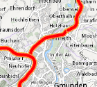
Schwertransportrouten
Die Verläufe der Schwertransportrouten in OÖ
Simple
Metadata
- File identifier
- AE91CF6C-4407-4445-90E2-B35791AB576E XML
- Metadata language
- de
- Metadata standard name
-
OENORM A 2270
- Metadata standard version
-
Ausgabe 2016
- Date stamp
- 2026-01-19T09:31:57.984Z
- Metadata author
-
Organisation name Individual name Electronic mail address Role Amt der Oö. Landesregierung
Mag., Michael, Beham
Point of contact
- Hierarchy level
- Dataset
- Dataset URI
-
H:\arcgis\Layerfiles\Verkehr\Verkehrswesen\Schwertransportrouten.lyr
Identification
- Alternate title
-
DORIS_V.GISDB.SCHWERTRANSPORTROUTEN
- Date ( Creation)
- 2017-10-02
- Date ( Publication)
- 2017-10-09
- Presentation form
- Digital map
- Point of contact
-
Organisation name Individual name Electronic mail address Role Amt der Oö. Landesregierung
Dipl.-Ing., Hubert, Reiter
Point of contact
Descriptive keywords
- OGD Categories
-
-
Geographie und Planung
-
Verkehr und Technik
-
- OGD Keyword
-
-
Schwertransportrouten
-
GIP
-
Routen
-
Schwertransport
-
- Keywords
-
-
Schwertransportrouten
-
GIP
-
Routen
-
Schwertransport
-
Internetfreigabe
-
OGDFreigabe
-
Legal constraints
- Use limitation
-
no limitations
Legal constraints
- Access constraints
- Other restrictions
- Other constraints
-
Creative Commons Namensnennung 4.0 International (CC BY 4.0) https://creativecommons.org/licenses/by/4.0/deed.de
- Classification
- Unclassified
Technical information
- Spatial representation type
- Vector
- Denominator
- 1
- Metadata language
- de
- Character set
- UTF8
- Topic category
-
- Transportation
Spatial Information
))
Temporal extent
Temporal extent
Data quality information
- Hierarchy level
- Dataset
- Statement
-
Bei den Daten handelt es sich um einen Export der Verortungsobjekte "Schwertransportrouten" aus der GIP.
Conformance result
- Date ( Creation)
- 2017-10-02
- Date ( Publication)
- 2017-10-09
- Explanation
-
keine
- Pass
- No
Reference System Information
- Projection
- EPSG:31255
Distribution Information
- Distribution format
-
Name Version Specification shapefile 1.0
ESRI Shapefile Technical Description
Overviews
Spatial extent
Provided by
