 DORIS Geodaten-Katalog
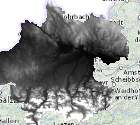
Digitales Geländemodell (DGM) als 10m-Raster Oberösterreich
Digitales Geländemodell als 10m-Raster, abgeleitet aus den aktuellsten Airborne Laserscanning (ALS) Befliegungen im Landeskoordinatensystem GK-M31 (EPSG: 31255) mit österr. Gebrauchshöhen (EPSG: 5778).
Simple
- Alternate title
-
DORIS_Rasterdaten.GISDB.DGM_10M
- Date (Creation)
- 2013-07-13
- Date (Publication)
- 2013-07-13
- Date (Revision)
- 2026-04-24
- Citation identifier
- https://data.inspire.gv.at/0021/C37B02D1-501F-4001-8F67-891094A4CB7B
- Point of contact
-
Organisation name Individual name Electronic mail address Role Amt der OÖ. Landesregierung
MSc, Bernhard, Kosar
Point of contact
- Maintenance and update frequency
- Unknown
-
OGD Kategorien
-
-
Geographie und Planung
-
-
OGD Keyword
-
-
Höhe
-
DGM
-
DHM
-
ALS
-
- Keywords
-
-
Höhe
-
DGM
-
DHM
-
ALS
-
Internetfreigabe
-
OGDFreigabe
-
OGDnoExport
-
- Use constraints
- Other restrictions
- Other constraints
- Creative Commons Namensnennung 4.0 International (CC BY 4.0)
- Other constraints
-
Datenquelle: Land Oö., doris.at
- Access constraints
- Other restrictions
- Classification
- Unclassified
- Spatial representation type
- Grid
- Language
- Deutsch
- Character set
- UTF8
- Topic category
-
- Elevation
N
S
E
W
))
- Unique resource identifier
- EPSG:31255
- Number of dimensions
- 3
- Cell geometry
- Area
- Transformation parameter availability
- No
- Distribution format
-
Name Version GeoTIFF
1.0
- Distributor contact
-
Organisation name Individual name Electronic mail address Role Land Oberösterreich - Amt der OÖ- Landesregierung
Digital transfer options
- OnLine resource
-
Protocol Linkage Name https://e-gov.ooe.gv.at/at.gv.ooe.dorisdaten/DGM_10M_XYZ.zip https://e-gov.ooe.gv.at/at.gv.ooe.dorisdaten/DGM_10M_TIF.zip
Metadata
- File identifier
- C37B02D1-501F-4001-8F67-891094A4CB7B XML
- Metadata language
- Deutsch
- Character set
- UTF8
- Hierarchy level
- Dataset
- Date stamp
- 2026-04-24T07:40:46.155Z
- Metadata standard name
-
ISO 19115:2003/19139
- Metadata standard version
-
1.0
- Metadata author
-
Organisation name Individual name Electronic mail address Role Amt der OÖ. Landesregierung
MSc, Bernhard, Kosar
Point of contact
- Dataset URI
-
H:\arcgis\Layerfiles\DORIS_Rasterdaten\Digitales_Gelaendemodell_DGM_10mRaster.lyrx
Overviews
Spatial extent
N
S
E
W
Provided by

Associated resources
Not available