 DORIS Geodaten-Katalog
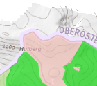
Herkunftsgebiete Mühlviertel
Lage und Höhe der Herkunftsgebiete im Mühlviertel des Saatgutes für die Forstwirtschaft. Rechtl. Grundlage ist die Forstliche Vermehrungsgutverordnung 2002 und die Verordnung Forstliches Vermehrungsgut BGBl.Nr. 512/1996 ST0163.
Simple
Metadata
- File identifier
- CC82DCA1-D988-4A9C-9743-E124C15CF2A0 XML
- Metadata language
- de
- Character set
- UTF8
- Metadata standard name
-
OENORM A 2270
- Metadata standard version
-
Ausgabe 2016
- Date stamp
- 2026-03-23T15:50:02.539Z
- Metadata author
-
Organisation name Individual name Electronic mail address Role Amt der Oö. Landesregierung
Dipl.-Ing., Roland, Paumann
Point of contact
- Hierarchy level
- Dataset
- Dataset URI
-
H:\arcgis\Layerfiles\PlanungEntwicklung\Grenzen\Herkunftsgebiete Mühlviertel.lyr
Identification
- Alternate title
-
DORIS_PE.GISDB.HERKUNFTSGEBIETE_MUEHL
- Date ( Publication)
- 2008-09-12
- Date ( Creation)
- 2008-01-01
- Date ( Revision)
- 2008-09-12
- Point of contact
-
Organisation name Individual name Electronic mail address Role Landesregierung Oberösterreich, Abteilung Land- und Forstwirtschaft
Dipl.-Ing., Roland, Paumann
Point of contact
Descriptive keywords
- OGD Kategorien ( Theme)
-
-
Geographie und Planung
-
Umwelt
-
- OGD Keyword
-
-
Herkunftsgebiete des Saatguts für die Forstwirtschaft
-
Saatgutbeschaffung
-
- Keywords
-
-
Herkunftsgebiete des Saatguts für die Forstwirtschaft
-
Saatgutbeschaffung
-
Internetfreigabe
-
OGDFreigabe
-
Legal constraints
- Use limitation
-
no limitations
Legal constraints
- Access constraints
- Other restrictions
- Other constraints
-
Creative Commons Namensnennung 4.0 International (CC BY 4.0) https://creativecommons.org/licenses/by/4.0/deed.de
- Classification
- Unclassified
Technical information
- Denominator
- 1
- Metadata language
- de
- Character set
- UTF8
- Topic category
-
- Farming
- Biota
Spatial Information
))
Temporal extent
Temporal extent
Data quality information
- Hierarchy level
- Dataset
- Statement
-
Die Abgrenzung erfolgte auf Basis der textuellen Beschreibung in der Vermehrungsgutverordnung 2002, Anhang IX.
Conformance result
- Date ( Creation)
- 2010
- Explanation
-
unbekannt
- Pass
- No
Reference System Information
- Projection
- EPSG:31255
Distribution Information
- Distribution format
-
Name Version Specification shapefile 1.0
ESRI Shapefile Technical Description
Overviews
Spatial extent
Provided by
