 DORIS Geodaten-Katalog
Hangwasserhinweiskarte 2.0: Fließpfade
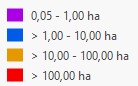
Rasterdatensatz zur Darstellung der potenziellen Konzentration des oberflächlichen Abflusses in Oberösterreich. Der Datensatz basiert auf einer mit QGIS berechneten Fließakkumulation und wurde anhand der jeweils oberhalb entwässernden Einzugsgebietsfläche in vier Klassen eingeteilt. Flächen unter 500 m² beziehungsweise 0,05 ha wurden als NoData ausgewiesen. Die räumliche Auflösung beträgt 1 × 1 m.
Legende: https://doris.at/images/legenden/Legende_Hangwasserhinweiskarte_Fliesspfade.jpg
Simple
Metadata
- File identifier
- dfb3c664-bd8a-4f86-a221-b31cf8d04033 XML
- Metadata language
- de
- Character set
- UTF8
- Metadata standard name
-
OENORM A 2270
- Metadata standard version
-
Ausgabe 2016
- Date stamp
- 2026-10-27T12:52:58.2694487Z
- Metadata author
-
Organisation name Individual name Electronic mail address Role Land Oberösterreich
Heim Prisca, BSc MSc
Point of contact
- Dataset URI
-
H:\arcgis\Layerfiles\Umwelt\Geowissenschaften\Hangwasserhinweiskarte.lyrx
Identification
- Alternate title
-
H:\d_hangwasserhinweiskarte\Hangwasserhinweiskarte.gdb
- Date ( Creation)
- 2026-06-23
- Date ( Publication)
- 2026-10-27
- Date ( Revision)
- 2026-10-27
- Point of contact
-
Organisation name Individual name Electronic mail address Role Walter Torben, MA.rer.nat
Point of contact
Descriptive keywords
- OGD Kategorien ( Theme)
-
-
Umwelt
-
- OGD Keyword ( Theme)
-
-
Geländemodell
-
hydrologische Modellierung
-
Einzugsgebiet
-
Abflusskonzentration
-
Oberflächenabfluss
-
Flow Accumulation
-
Fließakkumulation
-
Internetfreigabe
-
OGDnoExport
-
OGDFreigabe
-
- Keywords
-
-
Geländemodell
-
hydrologische Modellierung
-
Einzugsgebiet
-
Abflusskonzentration
-
Oberflächenabfluss
-
Flow Accumulation
-
Fließakkumulation
-
Legal constraints
- Use limitation
-
no limitations
Legal constraints
- Access constraints
- Other restrictions
- Other constraints
-
Creative Commons Namensnennung 4.0 International (CC BY 4.0) https://creativecommons.org/licenses/by/4.0/deed.de
Security constraints
- Classification
- Unclassified
Technical information
- Denominator
- 1
- Metadata language
- de
- Character set
- UTF8
- Topic category
-
- Inland waters
- Geoscientific information
- Elevation
Spatial Information
))
Temporal extent
Temporal extent
Data quality information
- Hierarchy level
- Dataset
- Statement
-
Die Fließakkumulation wurde in QGIS auf Basis eines digitalen Geländemodells mit 1 m Rasterweite berechnet. Anschließend erfolgte die Klassifizierung der beitragenden Fläche: unter 500 m² = NoData, 500 m² bis 1 ha = Klasse 1, > 1 bis 10 ha = Klasse 2, > 10 bis 100 ha = Klasse 3 und > 100 ha = Klasse 4. Die Ausgabe erfolgte als GeoTIFF mit 1 × 1 m Auflösung
Reference System Information
- Projection
- EPSG:31255
Distribution Information
- Distribution format
-
Name Version Specification shapefile 1.0
ESRI Shapefile Technical Description
Overviews
Spatial extent
Provided by